

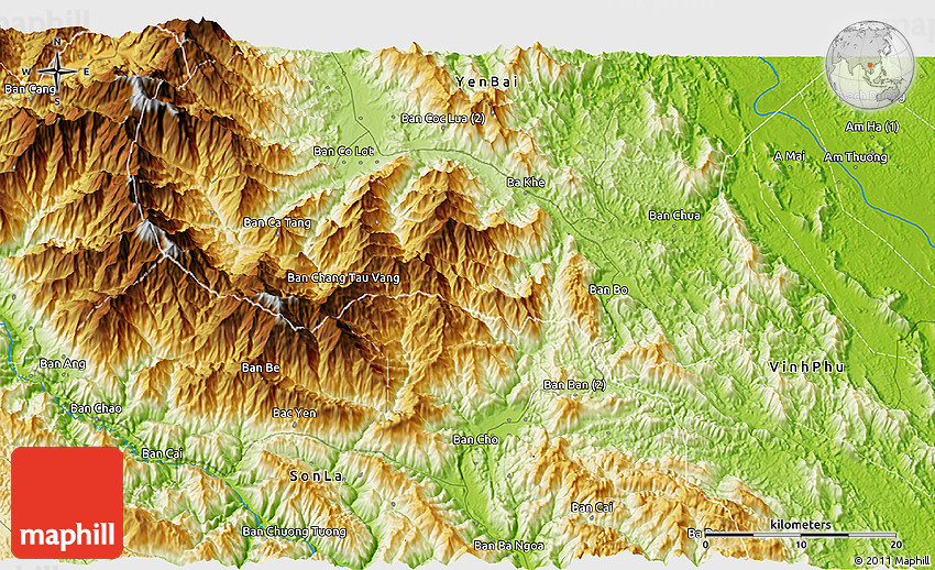
Physical 3D Map of Bản Sông Xi
This is not just a map. It's a piece of the world captured in the image.
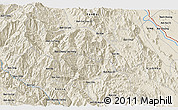
The 3D physical map represents one of many map types and styles available. Look at Bản Sông Xi, Tram Tau, Yen Bai, Vietnam from different perspectives.
Get free map for your website. Discover the beauty hidden in the maps. Maphill is more than just a map gallery.

Satellite
Political
Physical
Shaded Relief
Maps of Bản Sông Xi
Maphill is a collection of map images. This view of Bản Sông Xi at an angle of 60° is one of these images. Click on the Detailed button under the map for a more comprehensive map.
See Bản Sông Xi from a different perspective.
Each map type has its advantages. No map style is the best. The best is that Maphill lets you look at each place from many different angles.
Sure, this physical 3D map is nice. But there is good chance you will like other map styles even more. Select another style in the above table. See Bản Sông Xi and Yen Bai from a different view.
What to do when you like this map?
If you like this Bản Sông Xi, Tram Tau, Yen Bai, Vietnam map, please don't keep it to yourself. Give your friends a chance to see how the world converted to images looks like.
Share this 3D map.
Use the buttons for Facebook, Twitter or Google+ to share a link to this physical map of Bản Sông Xi. Maphill is the largest map gallery on the web. The number of maps is, however, not the only reason to visit Maphill.
Get 3D map of Bản Sông Xi for free.
You can embed, print or download the map just like any other image. All Bản Sông Xi and Yen Bai maps are available in a common image format. Free images are available under Free map link located above the map.
Is there anything more than this map?
Sure, there is. It has been said that Maphill maps are worth a thousand words. No doubt about that. But you can experience much more when you visit Bản Sông Xi.
Be inspired.
Yen Bai has a lot to offer. Each place is different. Each place is worth a visit. It will never be possible to capture all the beauty in the map.
Bản Sông Xi hotel deals.
If any of Maphill's maps inspire you to come to Bản Sông Xi, we would like to offer you access to wide selection of nearby hotels at low prices and with great customer service.
Thanks to our partnership with Booking.com you can take advantage of up to 50% discounts for hotels in many locations in the area of Yen Bai. Book hotels online and save money.
Bản Sông Xi hotels
See the full list of hotels in or close to Bản Sông Xi, the list of destinations in Tram Tau, browse destinations in Yen Bai, Vietnam, Asia or choose from the below listed cities.
Hotels in popular destinations in Tram Tau
Learn more about the map styles
Each map type offers different information and each map style is designed for a different purpose. Read about the styles and map projection used in the above map (Physical 3D Map of Bản Sông Xi).
Physical map
Physical map illustrates the mountains, lowlands, oceans, lakes and rivers and other physical landscape features of Bản Sông Xi. Differences in land elevations relative to the sea level are represented by color.
Green color represents lower elevations, orange or brown indicate higher elevations, shades of grey are used for the highest mountain ranges in the world. Underwater topography is represented by blues. Darker blues are used for the deepest water, lighter shades of blue represent shallower water such as the continental shelf.
Plate Carree map projection
A map projection is a way how to transform points on a Earth to points on a map. This 3D map uses Plate Carree projection, a simple variant of the equidistant cylindrical projection originated in the ancient times. The parallels and meridians are equally spaced, they together form equally sized squares over the entire world map.
Using simple grid, where each cell has the same size and shape, brings in significant benefits. For comparison, the detailed maps of Bản Sông Xi use Mercator projection instead. The Mercator projection preserves the shapes and angles of small areas better, but on the other hand, it significantly distorts the size of areas.
Facts
Locations near Bản Sông Xi
Destinations close to Bản Sông Xi sorted by distance.
- Bản Sông Xán 1.9 km
- Bản Na Tai 3.4 km
- Trạm Tấu 3.7 km
- Bản Na Tiêu 3.9 km
- Bản Sen Cốc 4.1 km
- Giá Cao 6.4 km
- Bản Nang Phai 6.4 km
- Nậm Tục 6.5 km
- Bản Thòn 6.9 km
- Bản Ve 7.1 km
Popular searches
A list of the most popular locations in Vietnam as searched by our visitors.
Recent searches
List of the locations in Vietnam that our users recently searched for.

The Maphill difference
It's neither this physical 3D map nor any other of the many millions of maps. The value of a map gallery is not determined by the number of pictures, but by the possibility to see the world from many different perspectives.
Technology
We unlock the value hidden in the geographic data. Thanks to automating the complex process of turning data into map graphics, we are able to create maps in higher quality, faster and cheaper than was possible before.
Forever free
We created Maphill to make the web a more beautiful place. Without you having to pay for it. Maphill maps are and will always be available for free.
Real Earth data
Do you think the maps are too beautiful not to be painted? No, this is not art. All 3D maps of Bản Sông Xi are created based on real Earth data. This is how the world looks like.
Easy to use
This map is available in a common image format. You can copy, print or embed the map very easily. Just like any other image.
Different perspectives
The value of Maphill lies in the possibility to look at the same area from several perspectives. Maphill presents the map of Bản Sông Xi in a wide variety of map types and styles.
Vector quality
We build each 3D map individually with regard to the characteristics of the map area and the chosen graphic style. Maps are assembled and kept in a high resolution vector format throughout the entire process of their creation.
Experience of discovering
Maphill maps will never be as detailed as Google maps or as precise as designed by professional cartographers. Our goal is different. We want to redefine the experience of discovering the world through the maps.
Fast anywhere
Maps are served from a large number of servers spread all over the world. Globally distributed map delivery network ensures low latency and fast loading times, no matter where on Earth you happen to be.
Spread the beauty
Embed the above physical 3D map of Bản Sông Xi into your website. Enrich your blog with quality map graphics. Make the web a more beautiful place.
